What the river did to North Bundaberg
In January 2013, after ex-Tropical Cyclone Oswald, the Burnett River at Bundaberg peaked at 9.53 metres, the highest level on record and above the 1890 flood of 9.04 metres. The council's own account of that event says more than 4,000 homes were inundated and about 5,000 people were evacuated from North Bundaberg, with flood depths up to 3 metres and water moving at up to 5 metres a second through the streets on the northern bank. In December 2010 the river had reached 7.92 metres. On 26 March 2026 it rose above the 7.40 metre major flood level again, the highest since 2013. The Bureau of Meteorology's Burnett River flood history lists every major peak back to 1890.
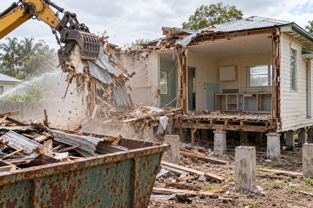
That history shapes what demolition looks like on this side of the river. The jobs are rarely a tidy knock-down of a sound house. They are houses flooded to the ceiling and never properly dried, low-set brick and fibro homes with mould in the cavities, timber homes lifted off their stumps by moving water, and the odd house that has stood empty since 2013.
| Year | Peak at Bundaberg | Note |
|---|---|---|
| 1890 | 9.04 m | Highest flood before 2013 |
| 1942 | 8.48 m | Wartime flood |
| Dec 2010 | 7.92 m | Two years before the record |
| Jan 2013 | 9.53 m | Record; over 4,000 homes inundated, about 5,000 evacuated from North Bundaberg |
| Mar 2026 | Above 7.40 m | Above the major flood level, highest since 2013 |
Demolishing a flood-damaged house
A flood-damaged house changes the usual sequence in three ways. First, the asbestos question is harder. WHSQ presumes asbestos in any building built before 31 December 1989 until a sample shows otherwise, and much of the housing in North Bundaberg, Kalkie and the older parts of Gooburrum broadly predates that, but flooding tends to break fibro sheets, lift vinyl tiles and leave debris in the cavities and under the floor. A licensed removalist cannot simply unscrew intact sheets and stack them on plastic; broken fibro has to be handled wet and bagged, and the clearance inspection after Class B removal looks harder at the sub-floor. See the asbestos rules for the licence classes and the Form 65 notice.
Second, the structure may not be stable. Water moving at several metres a second pushes houses off their stumps, racks frames and undermines slabs. The contractor's safe work method statement for removing load-bearing elements has to account for a frame that may already be partly collapsed, and a structure collapse during demolition is a notifiable dangerous incident under the WHS Regulation. Any demolition using an excavator, loader or skid steer requires the WHSQ demolition work licence regardless of the building, and the WHSQ demolition licence page publishes a list of licensed contractors.
Third, the contents. A flood house shut up for years usually still holds mud and ruined furniture, which is general waste at $359 a tonne from 1 July 2026 and has to go before a strip-out of any salvageable hardwood can start.
The Flood hazard overlay and code assessment
The Flood hazard overlay in the Bundaberg Regional Council Planning Scheme 2015 has three parts: main river flooding, localised flooding and coastal storm tide. Low-lying land along the river, which can include much of North Bundaberg, Fairymead and the lower parts of Gooburrum and Kalkie, may sit within the main river part; check the mapping, and the council's Burnett River flood information page maps the 2013 extent. Where the flood overlay triggers code assessment, council charges no fee for that trigger; the certifier confirms what the overlay means for the demolition and the rebuild. Demolition itself still goes through a QBCC-licensed private certifier as building work under the Building Act, and under section 71 the work must substantially start within two months of approval and finish within a year, with one extension of up to six months available from the council; the certifier confirms the current conditions.
Where the overlay bites is the rebuild. New building work in the flood hazard area is typically code assessable against the flood hazard overlay code, which sets floor levels and sometimes the type of construction below the defined flood level. The council's 2026-27 fee schedule lists code assessment triggered only by the Flood hazard overlay at no charge. If the lot is also in the Heritage and neighbourhood character overlay, which some of the older streets near the river may be, the same no-fee rule applies for overlay-only assessment; a development application is still required before demolishing a Victorian, Federation or Interwar building in a mapped character area. The council duty planner on 1300 883 699 can tell you both things for your lot before you engage a certifier.
Raise it or pull it down?
Raising a timber house above the defined flood level is a real option on this side of the river, and so is relocating it. Demolition is the other option. The demolition contractor is the wrong person to ask about the structural side; a builder and an engineer are. But there are a few things a contractor can tell you.
A house that was shifted off its stumps by the 2013 water, or that has been shut up wet for a decade, often has a frame that is no longer worth the cost of lifting. A brick veneer or masonry home cannot be raised in any practical sense, so the choice there is between a flood-resilient refit and demolition. A sound pre-war timber home on a high block in Kalkie, by contrast, may be worth keeping, and if it is in a character area the planning scheme leans that way too. Our guide on whether to demolish or remove a Queenslander sets out the removal route, including the council's April 2026 policy. Council is a referral agency under its April 2026 policy and no longer requires a bond; ask council or the certifier what supporting reports (typically a structural engineer's report and transport route) the referral needs. Council's April 2026 removal policy requires a removal site to be cleared of debris, stumps, foundations and wastewater systems, and builders expect the same of a demolished block.
Grey Burnett clay and getting a machine onto the block
The soil on the river flats is the reason the flats flood and the reason they grew cane. King's 1949 survey described the Burnett series as grey alluvial silty and clay loams grading to heavy clays, laid down by the river across North Bundaberg, Bingera and Fairymead. It is good cane country and poor demolition country. After rain the grey clay holds water, tracks churn it into ruts, a loaded tipper can bog in a front yard, and the stump holes fill with water as fast as they are dug.
For a demolition that means three things. Timing matters: a contractor will try to avoid pulling stumps and footings on the flats in the wet season, and may track a machine in on mats or crushed rock. The waste tonnage goes up: wet clay clinging to concrete and stumps is weighed at the tip along with everything else, and dirty fill is charged at $274 a tonne rather than the free rate for clean fill under 100 mm. And the block will need attention afterwards: a hole left where a slab or septic tank came out of grey clay becomes a pond, and the block needs to be left level for the next builder. North on the forest flats around Gooburrum the soil changes to the reddish Gooburrum sandy loams, which drain better.
Fairymead, Gooburrum and Kalkie: the mill country
North of the river the history is sugar. Fairymead mill opened in 1884 on the flats, and the cane railways that fed it and the other mills still run across the district; the council's Infrastructure overlay maps them, and a demolition site that backs onto a cane line has to keep the line clear. Fairymead's old mill cottages, barracks and farm sheds are a regular source of small jobs; see our shed and garage page. Gooburrum is the forest flat country north and west of the town, part farms and part rural residential, where a demolition is as likely to be a derelict farmhouse or a packing shed as a suburban home. Kalkie, on the rising ground to the east, has much of the older timber housing on this side of the river, broadly speaking.
The waste from all of these runs down to the Bundaberg Waste Facility at 46 University Drive, open Monday to Friday 7 am to 5 pm and 8 am to 5 pm on weekends, which is the only council facility accepting asbestos. Construction and demolition waste is $359 a tonne with a $45 minimum, clean concrete $240 a tonne, green waste $160 a tonne, asbestos $208 a tonne, all from 1 July 2026. The state levy ($135 a tonne in 2026-27) applies to landfill in the Bundaberg region; ask council how it is reflected in the gate fee. A skip or stockpile on the road reserve needs a Use of Road Reserve permit at $550.
Services are the same as anywhere in the region: electricity removal through the retailer with Ergon's written confirmation before work starts, water and sewer disconnected by council staff on the Notice to Service Provider form, gas and NBN arranged separately. A flood house that has had its meter removed years ago by Ergon after the flood still needs the retailer to confirm the connection is abolished before the excavator moves in. The checklist covers the full list, and the quote form asks the questions a contractor needs answered for a flats job: when it last flooded, how high, and whether the house moved.
What this page cannot do
This page cannot tell you whether your house is structurally worth raising, relocating or demolishing; that is an engineer's and a builder's call, not a demolition contractor's. It cannot tell you the defined flood level for your lot or what floor height a new house will need; the council's flood mapping and the certifier set that. It does not issue approvals, does not quote the demolition work, and does not replace the asbestos sample that tells you what is actually in a flood-damaged fibro house. Use it to understand what is different about demolition on the river flats, then ask the council, the certifier and a licensed contractor about your own block.
Check the current rules before you rely on this
This page describes demolition of flood-affected and other houses in North Bundaberg, Fairymead, Gooburrum and Kalkie on the Burnett River flats. It describes the rules in general terms as they stood in October 2026. Standards, forms, thresholds and fines change.
The authoritative sources are Bureau of Meteorology, Burnett River flood warning brochure, Bundaberg Regional Council, Burnett River flood information, Bundaberg Regional Council planning scheme overlays factsheet, Building Act 1975 section 71, when demolition and removal must start and be completed, Bundaberg Regional Council Amenity and Aesthetics and Removal or Rebuilding Policy 2026 and King 1949, Soils of the Bundaberg district, Queensland Journal of Agricultural Science. Where anything here differs from those sources, they are right and we are not.
We are not building certifiers, engineers, planners or lawyers. For what applies to your property, ask a licensed building certifier or ring Bundaberg Regional Council on 1300 883 699.
Accurate at the time of writing, October 2026. Always check the source before relying on it.